What kind of weather should you expect in the Dolomites? In the mountains? When is the best time to visit the Dolomites? The weather report here on VIVODolomites can tell you immediately. The weather forecast and weather data are always up to date for your holiday in the Italian Dolomites. This enables you to plan your outdoor activities perfectly, because those who want to go hiking, cycling or skiing in the Dolomites, would obviously prefer to avoid any wet surprises from above.
|
The high-pressure system will temporarily strengthen, bringing stable weather with summer-like conditions.
|
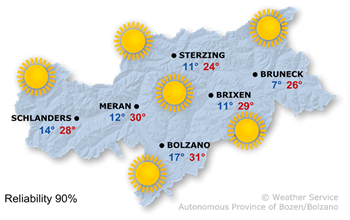
Very sunny weather with generally clear skies. The Föhn will continue to blow in the valleys in the north.
Maximum temperatures between 23° and 31°.
|
Excellent conditions for hikes, even long ones. The sun will shine all day, and the cumulus clouds in the afternoon will not develop vertically. Winds will pick up on the peaks.
|
|
Although a high-pressure system will continue to dominate the weather, the atmospheric conditions will become slightly more unstable.
|
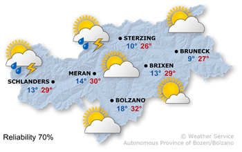
Apart from some low stratus clouds in the morning, it will be sunny across much of the region. As the afternoon progresses, a few cumulus clouds will form, leading to isolated thunderstorms, most likely in the west and north of South Tyrol.
The highest temperatures will range from 25° to 32°.
|
To begin with, conditions are favourable. It will be mostly sunny, with some slope clouds in places. As the afternoon progresses, the likelihood of thunderstorms will increase slightly from the west.
|
Sunday

Temp. max: 28°C
Temp. min: 14°C
|
Monday

Temp. max: 32°C
Temp. min: 13°C
|
Tuesday

Temp. max: 33°C
Temp. min: 14°C
|
|
On Sunday, the weather will become more changeable. Although there will be sunny spells, thunderstorms are possible in places already in the first half of the day, becoming more frequent in the afternoon.
Monday will bring fairly sunny weather, with temperatures rising slightly again.
On Tuesday, it will be very sunny again.
Wednesday will also start off with plenty of sunshine, but the likelihood of thunderstorms will increase in the second half of the day.
|
|
|
|
Source: Hydrographic Office of the Autonomous Province of Bolzano
|